Tuesday, June 18, 2013

Hightop Mountain hike

Hightop Mountain is the tallest park in the southern district of Shenandoah National Park (between Swift Run Gap and Rockfish Gap). The Appalachian Trail goes very near the summit and a short side path leads to an outstanding views to the south and west. This viewshed looks right down on the area that was once owned by Frances Shiflett and later John William Allen. I have attempted to annotate the picture below with an outline of the land as well as some significant local landmarks. Click on the image to view it at full size.
 

The outline of the land is just an estimate and the lower elevations of the land are obscured a bit by the ridges in the foreground.


large boulders along the trail


The hike itself is a very pleasant one. It's approximately 1.5 miles each way from the Hightop parking area on the Skyline Drive. The elevation gained is about 950 feet, so it's a bit steep. The trail, actually the Appalachian Trail, is in very good condition.


View towards Swift Run and Elkton
The hike begins by passing through a small clearing that is beginning to become overgrown. It then passes through an area with many large boulders alongside the trail. In May, the area reportedly is covered with many trillium flowers. 
 
Ferns and flowers near the summit
This deer watched us from right off the trail
The boulders fade away as you climb more steeply. Many ferns begin to appear along the trail. Soon you approach the summit. The first path on the right leads to a rock outcrop without a view. This one should be skipped. The second one provides the viewpoint seen at the top of the page.  If you continue a few yards down the trail, you'll come to a concrete marker. A smaller path to the left will take you a couple hundred yards to the summit of Hightop. There's no view from there, but you can see the remains of an old fire tower. 

Lucy also enjoyed her hike

Sunday, June 16, 2013

David Epperson Grave - Follow Up

This is a follow up to a previous post on the cemetery containing David Epperson's grave. See that story here.

It's fairly obvious that the gravestone of David Epperson was placed there well after his death (just consider the good condition and more modern design of it). But when was it done, and by who? Well, we may now have the answer thanks to the October 20, 1937 edition of the Richmond Times Dispatch. A marker to David Epperson was placed by the Jack Jouett Chapter, Daughters of the American Revolution and unveiled on October 15, 1937. See the headline below.


Do we know for that this is the marker described in the story? No. However it's definitely not the Sons of the American Revolution medallion that is being talked about that currently stands right next to the gravestone. My personal guess, based on the wear and tear on, and design of, the marker is that the gravestone is the one described in the newspaper. Feel free to share your thoughts!

Monday, March 4, 2013

Davis vs. Davis, 1890

I was recently browsing the Chancery cases on the Library of Virginia's website when I came across a case in Page County titled Jno. B. Davis & Others vs. Thos. J. Davis & others. Among the surnmames listed as parties to the case was the name Maiden, so this caught my eye. A quick search at the family tree on Ancestry.com found that Thomas J. and John Barton Davis were brothers of Anna (or Anne) Elizabeth Davis, wife of John Tyler Maiden and my great-great-great grandmother! So, this was obviously a case that involved our family and was worth looking into. Luckily the Library of Virginia had scanned in all of the pages associated with this case, and I was able to find out all of the details of the case and a lot of new things about that branch of our family tree.

Friday, January 27, 2012

Lawson House

It has been a while since we've posted here. The flow of new information slowed down, we got busy and we unfortunately didn't keep up with the blog. Well, I'm going to try to do a better job of posting things from time to time.

I'm going to start with a new find related to John William Allen.

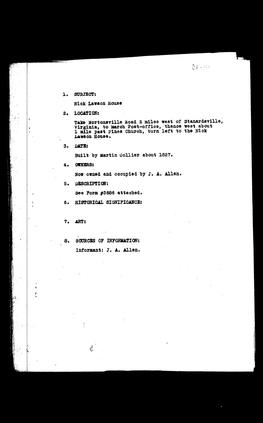
Today, I was searching the Library of Virginia site and came across a record for the Lawson House in the Virginia Historical Inventory. This collection was originally assembled by the Virginia Writer's Project, a part of the depression-era Works Progress Administration. It documented thousands of historic homes and sites across Virginia. You can search the collection here.

One of the entries in this collectino describes the Nick Lawson house. The location described in the pages below, matches that of John William Allen's homeplace. We also see that the owner and occupier of the house, as well as this report's informant, is listed as J. A. Allen. This would appear to be John Arthur, John William's son. The description of the house on page three also matches that of photos we have (see below). There is no doubt that we've found a record on the old Allen home.


So, we know this is the Allen home, so who was Nick Lawson?? As we've posted before, John William Allen purchased, in 1900, 166 acres of land in Greene County. A portion of that deed is listed here:

This Deed made this Oct 15, 1900 between F.M. McMullan [?] hereinafter
described of one part and John W. Allen of the other part. Whereas
said F.M. McMullan & R.S. Thomas [?] in the suit of H.S. Collier vs
Lawson in Greene Circuit Court in pursuant of the decree entered in
the said cause at Nov term 1894 of said court made public sale on
March 13, 1895 of the Martin Collier Home Place of 166 acres 2 roods
13 poles of land.


As you can see, the land that was purchased was called the Martin Collier homeplace. As it turns out, a Nicholas Lawson married a daughter, Texanna, of Martin Collier. The H. S. Collier mentioned in the deed is most likely Hudson S. Collier, a son of Martin Collier. Apparently there was an issue with the purchase or transfer of the land between Nicholas Lawson and Hudson Collier that allowed John Allen to purchase it.

Some more digging into Nicholas Collier reveals that is his full name was John Nicholas Lawson. He was born in 1841 in Rockingham County. As it turns out, the Lawsons were neighbors with the Maidens. Nicholas Lawson's family is listed immediately above William and Sarah Maiden (parents of John T. Maiden and grandparents of Mary Clementine Maiden Allen) in the 1860 census. Nicholas then married Texanna Collier and moved to Greene County.

It seems obvious now that there the Lawsons, Colliers, Maidens and later Allens all were closely associated with and knew each other well. More research is needed to find out the reasons behind the court case that led to John Allen's purchase of the land in Greene County.

Tuesday, March 22, 2011

David Epperson Cemetery


On Sunday, March 20th on our way home we made a detour south off of I 64 to Blue Ridge Farm off of Ortman Road near Greenwood in Albemarle County. Ortman road can be accessed from US 250 about 1.5 miles west of exit 107. The map at the bottom of the page shows the site.


Blue Ridge Farm is on the National Register of Historic Places. The main house was built in the mid 19th century by the Smith family. Randolph Ortman had the house enlarged in 1923. The work was done by renowned architect, William Lawrence Bottomly. The Epperson family seemingly owned land that at least partially makes up the current Blue Ridge Farm tract. In fact, the mountain just east of the current Blue Ridge Farm was once known as Epperson Mountain. John Epperson sold the land to the Durrett family in 1800 not long after his father David Epperson, Sr. died.

David Epperson was born in 1734. It is not known for sure who his parents were but it is thought that he was the son of John Epperson and Elizabeth and may have been born in New Kent County. In 1753, he married Hannah Thompson. David Epperson and family were patriots during the American Revolution. Both David Sr. and his son David Jr. enlisted and served. The elder David was in the 14th VA regiment. He also provided financial assistance to other volunteers who otherwise could not have afforded to leave their families. In 1776 his name appears on a dissenters petition for colonists who wished to be free of the Church of England.

Unfortunately, the younger David lost his life in the service of his new nation. He died at Valley Forge in 1777, leaving a young wife and children. It is from these young children that our line comes. David Epperson, Jr. married Judith Maupin. One of their daughters, Hannah Epperson, married Dillard Sandridge. Their child, Joel Maupin Sandridge had a daughter Elizabeth Sandridge who married Clifton Rice Wood Their daughter was Martha Frances "Fanny" Wood, wife of Algretus Rice Via. Another child of David Epperson and Judith Maupin was Anna. It is possible that Anna was a twin sister of Hannah. Anna married John Gardner. Their daughter, Sarah Harris Gardner was the wife of William Maiden. She is buried in the Maiden Cemetery in Rockingham County.


David Epperson, Sr. survived the war and died in late 1799. He was buried on his land and the cemetery remains to this day. Durretts are also buried there. The David Epperson marker is definitely not original. There is also a marker from the Sons of the American Revolution. The view from the cemetery is spectacular. We pulled up not knowing where to look for the cemetery, but a fenced in area was easily visible south of, and opposite the main house. I presumed this to be the cemetery. I happened across a farm hand who allowed me to drive the short way up the gravel road toward the cemetery. On the map below, the cemetery can be seen at the bottom center of the frame. By zooming in, you can easily make out the fenced in area that contains the cemetery.


View Larger Map

Monday, November 22, 2010

Return to the John A. Via Cemetery

On October 18, 2010, after leaving the Allen farm, we went back to the John A. Via cemetery in search of the remains of the home which we'd heard were nearby.

We parked the car at the same gate and climbed over. It was much less muddy this time, which made things easier! We walked immediately up to the cemetery and went through the gate. We found that the cemetery had been worked on recently. The Virginia Via reunion is held Columbus Day weekend and one of the reunion activities is to clean up Via family cemeteries, including this one. The John A. Via stone had been repaired and some brush had been cut back. The sign by the gate had been taken down for repairs but was due to be replaced soon.

After exploring the cemetery we moved up road behind it, just to see where it went. We had some information that described approximately where the house was, but wanted to explore all we could. Up this road we found bones of cattle and an old dozer. It seems that the dead cattle were carried up here to be butchered, but we're not sure. The road continued up the hill but we didn't follow it all the way. I believe it goes to the top of the mountain.


We returned to the cemetery and then set off to the west across the open pastures. We headed straight towards the western corner of the fields, where we had seen something that could have been the remains of a house on Google Earth. This along with our other information from Via family researchers turned out to be correct and we came across the remains of the home without having to really search at all.


The first thing that stands out is the old metal roof that covers much of the remains of the house. The wooden boards have fallen into the cellar and at a glance appear jumbled randomly. If you look closely though you can make out what was once the floor and the walls and you start to see how the house was situated.


We began to explore around the house and noticed that the nails were made by hand. This is a sure sign that this was a very old house. We also discovered some non-native plants, probably planted by the Vias growing around the house. There were also old bottles, and pieces of ceramic (see above). I'm not sure how old these might have been.


There is still a lot we don't know about the house. When was it built? When was it abandoned? When did it collapse? We were told by one source that there used to be a small village in the area, but that everyone moved out during the depression.

Enlarge the map below to see the relative locations of the cemetery and house.


This calf kept following Grandma! We had to shoo it away. Perhaps it was her red sweater tied around her waist. Check out its shifty eyes!

Tuesday, November 16, 2010

Visiting the John Allen family farm


On October 18, we had the opportunity to visit, and walk the grounds of the John William Allen family farm in Greene County. We were greeted by Tom Allen and his son Brad. Tom is the son of John Arthur Allen who in turn was the son of John William Allen. They showed us where the old house used to be. It stood directly behind the modern home at the front of the parcel, now occupied by Shelvia Jean Allen. All that is left is the well. The well once was part of the back porch. The picture to the right shows a couple of views of the house. The top photo shows construction of the modern house taking place directly in front of the old. Tom also mentioned that he was in possession of the still once owned by his grandfather. The still's top was removed when prohibition was enacted and from then on used to make apple butter. Hilda Allen recounted some memories of the old house. She particularly remembers the smells associated with visiting her grandparents. She recalled the smells of bread that Mary Maiden Allen would bake, and also of coffee, which Mary apparently drank frequently.


After Tom and Brad had to leave, we went down the hill below the farm and looked around the area where Allen family reunions were once held. The area has overgrown some, but the spring house is still visible. In the past, during reunions, tables were set up here where everyone sat and enjoyed a large meal. As a child, I remember playing in the creek and seeing the watermelons floating in the spring house to keep cool. We also saw a large pile of stones across the stream. It looks to be a particularly large example of a stone pile made from the clearing of a field. We do not know when this was done or who did it.

From the bottom of the hill we could look up at the old barn. We weren't sure exactly when it was built, but we are sure it was there during John William Allen's time. In viewing the barn from below we saw that this was near the spot where a photo was taken of my great grandfather Russell Allen with his brother George. See the photos below.


We wandered back across the land to another old building that has no doubt been around since the time of John Allen. Hilda Allen remembered this being where the sheep were kept. It is a very interesting building, looking almost like a home. It sits at the southern end of the property. Just north of this building was the spot where softball games were held during the reunions.

We next headed across the property to check out a small cemetery that Tom Allen had mentioned to us. This sits is to the east of the barn on land now owned by Stephanie Allen Deal. The deeds to the property describe the land as the old Martin Collier home place and mention a Collier family burial ground (see older blog posts) and we believe the two small field stones we found may indeed mark this Collier burial ground. Enlarge the photo below to see the two field stones. It is possible these mark the graves of the aforesaid Martin Collier and his wife.

All in all we had a great time exploring the John William Allen family farm and we hope to do it again soon. It is in a beautiful setting with views towards Shenandoah National Park, Bacon Hollow and Powell Gap. It is quite possible that John William and Mary Maiden Allen brought their family from Rockingham to this new farm in 1901 by passing over Powell Gap and through Bacon Hollow. The farm house would have faced almost directly towards the spot that Johnnie Shiflett grew up with his mother Frances, almost as if it was looking back to the past, just as we had been doing on that day.


The Google Map below shows the barn (left) and modern house (right). Just south of the modern home is the site of the original John William Allen house.


View Larger Map